Lint's Coyote Dry Lake

Movie, Video and Commercial Filming Locations

25 Miles North of Barstow, CA


Home Page | Panoramic Lake View | Coyote Dry Lake Tour | Off Highway Roads Tour | Mar's Landscape Tour

Other Locations Tour | Barstow Area Maps | In-Town Services | Barstow Weather/Road Condition | Web Site Map


Satellite Radar Image - Page 3 of 3


Satellite Radar Image

 
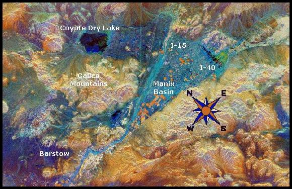
This satellite radar image shows part of the Mojave Desert in the vicinity north and east of Barstow, California. The dark patch in the upper left is the very smooth surface of Coyote Dry Lake. The V-shaped blue area in the center of the image is the Manix Basin, which includes the bed of the Mojave River.  Two major transportation corridors mark the sides of the "V".  Major railways and interstate highways (I-15 & I-40) follow these corridors.  Sparsely vegetated areas of sand and small gravel appear blue in this image, while rocky hills and rougher gravel deposits appear mostly in shades of orange and brown.  This image was acquired by the Space Shuttle Endeavour in 1994 and represents an area of approx. 30 miles by 46 miles wide.

Go to Lint's Coyote Dry Lake Home Page Panoramic Lake View, 1 page, 8 photos Coyote Dry Lake Tour, 7 pages, 28 photos Off Highway Roads Tour, 2 pages, 8 photos Mar's Landscape Tour, 2 pages, 6 photos Go to Lint's Home Page
Other Locations Tour, 3 pages, 9 photos 2 Barstow Area Maps, both printable In Town Services, phone numbers included Barstow Weather and Road Conditions Go to the Web Site Map Go Back to Maps Page 2